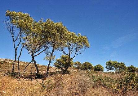
The superb natural surroundings of Oropesa del Mar provide hiking enthusiasts with numerous options. All along the various paths in the local area, you can gaze upon stunning landscapes where the sea, the mountains, and the orange and almond groves play the starring roles, while also discovering the typical flora and fauna of the region as you wander along each of these wonderful pathways.
You can choose from among 5 routes of varying levels of difficulty and length, as well as another 4 alternative routes, which will allow you to discover every last twist and turn of our beauty spots.
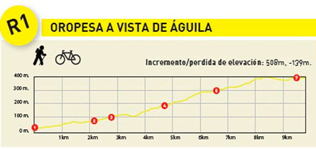
The route begins at the roundabout on the way into the town as you enter via the N-340 dual carriageway, next to the petrol station.
From there, take Avenida Benicàssim, then take the first right and, after walking for about 100 m, turn left just before the bridge.
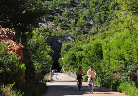
When you reach the crossroads, take the path to the right. After about 100 m, turn left once again. At this point, the trail returns to the gully last seen in the pine wood. Cross the gully, which is normally dry, to the other side where there is a tunnel. This tunnel crosses under the AP-7 (it is not advisable to take this tunnel when rainy).
Once at the other side, you will see the entrance to a go-kart racing track on your right.
When you get to the intersection, turn right and continue along the trail for about 300 m until you get to a fork in the path. Take the path on the right, until you get to the N-340 dual carriageway. To safely cross the N-340, walk down the right-hand side of the gully to pass under the road; at this point you are now in the foothills of the Sierra de Orpesa.
After exiting the tunnel, take the road to your left. From this point onwards, the gully will lie to your left, and as you ascend, it will become increasingly steep.
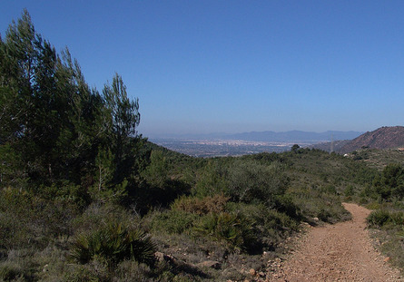
Continuing upwards, you will eventually find that the trail rises above the hills, which are now behind you. At this point you will see the blue horizon of the sea. If the day is clear, you will be able to see the silhouette of Las Columbretes archipelago. These volcanic islands are located about 35 km from the coast. The last part of the route is a little more challenging due to the steepness of the path, especially on hot days.
When you get to Jovellús well, which is surrounded by a number of farm houses, continue westward along the trail and you will soon come to a crossroad. From this point you will be able to see the Plana de Castellón at your feet. In the foreground you will see the towns of Benicàssim and Las Villas, while you will see the city of Castellón and its port, known as El Grao in the distance. The trail that descends to our left (the RAL-3) goes to Benicàssim. This is a good option for those who want to return to the coast. The trail on the right leads back to another fork, after a distance of 50 m. On the left you will soon pass another trail called La Vereda de la Mollonada – from here you can also take the RAL-4trail, which leads to the Camino de Cabanes – which runs through the Montes del Señor mountains and finally arrives to the television antenna. Behind you is a spectacular view of Las Agujas de Santa Águeda mountain range.
As you approach the television mast, you will come to the start of the R-2trail; though it is advisable to continue instead to the solar panels where you will enjoy a spectacular view before returning to the R-2.
This route begins just ahead of the TV mast, before the end of the R-1. It’s the trail on the left that heads north-east. It’s a small trail with some difficult sections near the beginning, in the form of steep slopes on a path that’s been heavily eroded by storm water flow. However, these inclines are only found at the beginning of the trail.
If you are an ATB enthusiast, this section is highly technical. If you are not an experienced rider then it is best to dismount and walk the bike up. The remainder of the trail is a slow downhill run between bush and old animal pens which exemplify the construction techniques of the past.
While on this trail you will pass through small pine woods and shady corridors of kermes. Near the end you will be coasting through mainly almond orchards which, when in bloom (end of January, beginning of February), offer a spectacular sight.
The trail ends at Cabanes road, about 3 km from the path to the TV mast and where the trail links up with the RAL-4. At this point in the trail, it’s time to call your loved ones to pick you up or instead you can return on foot, albeit cautiously, as you may encounter vehicles on the old Cabanes road. No matter what you decide, you will need to turn right. After about 1.5 km, turn right once more, this time onto another trail that runs through crop land and among some houses, until you get to the AP-7 motorway. The trail runs parallel to the AP-7 until you can cross the motorway by way of an underpass after nearly two kilometres. After about 500 m you will pass under the N-340 dual carriageway before arriving at Avenida Benicàssim. Finally, turn left here and after a few metres you will arrive at the roundabout located at the Guardia Civil quarters, the starting point for the R-1.
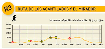
The starting point is found at the beginning of the Coastal Greenway. Walk for 1 km and a few metres before the tunnel entrance, you will see a sign on your left indicating the route you are about to take. Although this route isn’t overly difficult, it is important to pay attention to the signs and ensure that you pace yourself so that you’ll have some energy left to tackle some of the more challenging ascents.
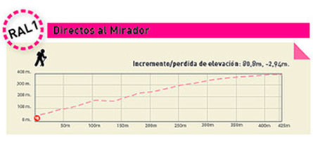
This route forks off after 100 m. The trail to the right is an alternate route which leads directly to the viewpoint (RAL-1) and it is approximately 430 m long with an elevation gain of 81 m. However, here you must take the trail on the left. This is a scenic route where the sea and the rocky faces of the cliffs take centre stage.
White and purple markers painted on rocks and tree trunks along the path will indicate the correct route. After approximately 2 km, you will arrive at the other side of the Coastal Greenway tunnel, at its exit, before crossing the Coastal Greenway.
At this point our trail heads upwards. Pay attention to the painted trail markers, as there are areas where the trail becomes less clear and runs among large rocks. After the ascent and upon arrival at the viewpoint, take a breath and enjoy the fantastic view from this privileged spot.
If you would like to turn back to the starting point, you can take the alternative route (RAL-1) which will take you directly back to the initial fork located near the Coastal Greenway tunnel entrance. If you would like to follow the main route, cross the road at the Viewpoint in the direction of the antenna, and follow the path that you will see straight away.
Once you pass the antenna, you will see a small wood where the route turns right; there you will see a sign indicating a fork. Take the path to the left and descend until you get to an olive grove. Turn right onto a new path, and follow this new path until you get to the road to the El Balcó urbanisation, which you will enter from Calle Benicàssim.
Taking this road, you will arrive at point where it is crossed by another road, also Calle Benicàssim. To your right, where it ends in a track, it will take you back to the antenna and from there, to the Viewpoint.
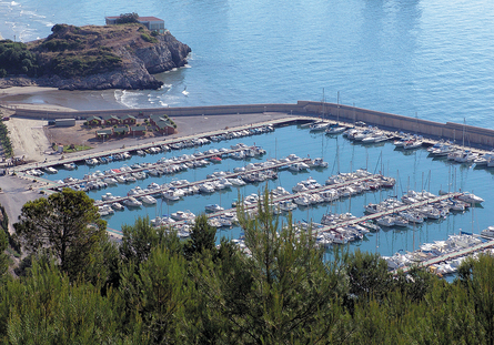
About 30 metres beyond the observation point, along Oropesa de Mar road, you will see some white and violet markers as well as a wooden sign just off the road, on the trail itself. The way down is quite steep until the trail meets a fire-break. As you cross it, head left to regain the trail which runs parallel to the firebreak until you are close to the Leisure port.
Take the path underneath the new train tracks. Do not cross under the Coastal Greenway bridge – instead, climb up its right side to the top. Once on the Coastal Greenway trail, it’s time to head back towards the starting point.
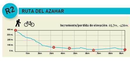
This route departs from the roundabout opposite the Plaza de Toros, very close to the Guardia Civil quarters, the starting point for the R-1 and the end of the R-2.
Start by walking along Calle Rivera Forner, turning right just a few metres further down onto Calle San Isidro. By taking this street you will soon leave the town and find yourself among fields and cropland, whilst gradually moving away from the N-340 dual carriageway.
After about 2 km, you will reach a tunnel which passes under a railway line. Do not take this tunnel. Instead, turn left towards the N-340 dual carriageway, taking the trail that runs along the left bank of the Chinchilla River.
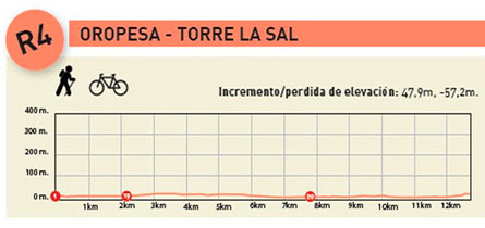
As you approach the N-340, the trail begins to run parallel to it. Walk around the various overpasses which cross the N-340, until you get to kilometre 3, approximately. At this point the trail will turn abruptly to the right, along the CV-146 road, towards Torre La Sal.
If you are in the mood for a swim, this is a good spot to do so. As you approach the beach, there is a trail on the right which will take you back to the starting point. This path links up with Avenida Barcelona. This street will get you to the Marina d’Or urbanisation and then to Oropesa del Mar town centre. If you wish to return to the beaches of Oropesa del Mar from Torre La Sal, take the R-5 and return along the sea.
To get to the starting point of this route, take Avenida Barcelona and turn onto Avenida del Mar until you get to Plaza España. Turn left on Calle Doctor Clará and turn right again on Calle Leoncio Serrano until you arrive at Calle Rivera Forner, which is the starting point.
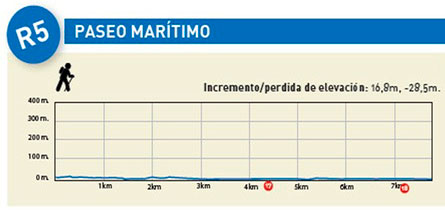
The best way to discover our coastline is on foot, along its promenades and other paved pathways that run along the sea.
The route distance given has been calculated from one end to the other, and does not take into account the return journey. Please bear this in mind so as to avoid surprises! This route is easy, and can be started at any point along the promenade – it all depends on your fitness level and the time you have at your disposal.
The route starts by the Leisure Port. After a slight ascent you will pass over the Retor and Orpesa la Vella Coves, the latter located on a hill where an Iberian settlement, with the same name, is located. After this section, the route heads down to sea level.
At La Concha Beach, the promenade starts to turn left and head uphill towards the famous Torre del Rey (King’s Tower), a nice example of Renaissance-style military architecture. Next to the tower you will find the Lighthouse, an example of Catalan Art Nouveau architecture. To your right you will see a stairway leading down to the rocks and Morro de Gos Beach.
Continue along the Seafront Promenade through the entire length of this beach until you get to Les Amplaries Beach. Once you get to the next roundabout you can continue walking on the fine sand or through the parks and gardens lining the urbanisation, until you arrive at the campsite area.
The last section of the route consists of a wooden walkway running between sand dunes in some sections and vegetation in others, which leads to Torre La Sal, a small seaside town untouched by the passing of time. If you wish to return, you can do so by retracing your steps or link up with the R-4 trail to return to Oropesa del Mar.
This is an alternative route which takes you directly to the Viewpoint starting from the first fork on the R-3route.
From here, if you have decided to take the direct route which starts on the right-hand side, you will soon find yourself climbing uphill from a height of 30 metres to 110 metres above sea level – an 80-metre climb in just 500 m of trail. Fortunately for hikers, this trail runs through a shady pine forest.
Once you arrive at the Viewpoint, you can take Route R-3 upwards to the surveillance antenna or back down to the Leisure Port.
This is an alternative route to the Oropesa del Mar – Benicàssim coastal trail, without the uphill climb to the Viewpoint. This trail follows paved walkways that link with the Coastal Greenway in Benicàssim.
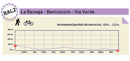
At the Rodecho Urbanisation, take the path indicated to the left (the path to the right links up with the R-1). After 70 m, go through the tunnel under the AP-7 road, which leads to La Renegà Urbanisation. Take the first path on the right. This path crosses the urbanisation at its highest point. This street ends after about 500 m at an intersection. From hereturn right, heading uphill.
Begin by heading uphill towards La Colomera Urbanisation. From here, you’ll have a magnificent view of the entire coastline and in particular, of the defensive monument which gives name to the urbanisation – La Torre Colomera (BIC).
From here, head downhill towards the Torre Bellver I urbanisation, until you arrive at a roundabout leading to Torre Bellver II. This route follows the N-340 dual carriageway and Oropesa del Mar along the coast. Turn left and you will soon get to Les Plategetes urbanisation. After crossing a bridge that passes over the Coastal Greenway, continue until you arrive at Voramar Beach in Benicàssim. At this point, the route links with the Coastal Greenway which will take you back to Oropesa del Mar, located at a distance of 5.7 km.
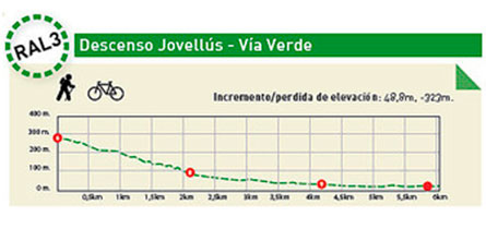
This mountain-biking route is an alternative to the R-1 route. Consisting of both dirt and paved trails, this route links with the Coastal Greenway in Benicàssim. Starting from Jovellús, take the path to the left. Take special care as you descend as this path consists of dirt and loose gravel.
You’ll enjoy stunning views of Las Agujas de Santa Águeda, Benicàssim and Castellón’s port. The paved section of the trail begins once you reach the Ecoparque. Pass through the tunnel located under the AP-7 motorway. After about 300 m the trail passes under the railway and 400 m further on it passes under the N-340 dual carriageway. Further down, the trail enters Benicàssim through Calle Santa Águeda. Turn onto Calle San Antonio and keep going until you get to Avenida Barcelona. From here, take the bicycle lane to go around the northern part of Benicàssim. Eventually you’ll reach Voramar Beach, where the Coastal Greenway begins. From here, you can start a pleasant 5.7 km ride back to Oropesa del Mar.
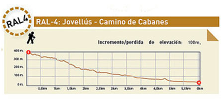
This is an alternative downhill route starting from La Vereda de la Mollonada (R-1) leading to the Camino de Cabanes, with approximately 2 km of a steep downhill slope at the beginning of the trail. After this section, the trail is well-conditioned for walking.
Go straight. After about 500 m you will see a trail turn off on your right. There will also be a couple of turn offs to the left, but you should stick to the same trail. Continue straight until you get close to the Camino de Cabanes, and then take Route R-2.